Himmeltinden (931 m.o.s.)
Himmeltinden is the highest mountain in Vestvågøy, measuring 962 metres above sea level. It is also the easiest mountain above 900 metres to climb in Lofoten.
Information about Himmeltinden
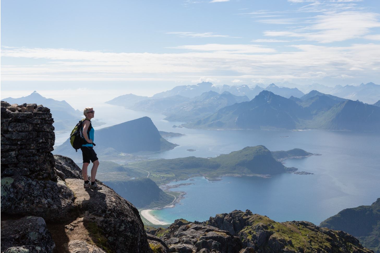
Himmeltinden is the highest mountain in Vestvågøy, and from the top you will have a view in all directions. The island is a favourite among mountain bikers and Smørdalskammen is the most popular bike route. Vestvågøy is also known for the surfing village Unstad, where you can rent a surfboard or book a surf course. From Unstad, you can follow the coastal path to the next village, Eggum where you see the sculpture called «Hode» (“the Head”), which is part of an outdoor art collection called Skulpturlandskap Nordland.
If it is rain and gale force wind from the south west, or you just want a break, we recommend a visit to the Viking museum or one of the goat farms nearby.
Leknes is a 20 minutes’ drive away from Himmeltinden. In Leknes you find everything you need of shops and services.
Parking at Haukland beach
Park at the large parking area at Haukland beach and start your walk here. Alternatively, you can start walking from Uttakleiv. To get to Uttakleiv, you drive through the Uttakleiv tunnel and park at the small parking by the old school.
Starting from either side, the walk follows the old cart road over the mountain above the Uttakleiv tunnel. From here you already have a wonderful view. At the highest point of the cart road the terrain becomes flatter. This is where you follow the path that starts by a big rock, leading eastwards and up through the Durmålsdalen valley. From here it goes straight up all the way!
Sore legs and sweet views
Even if the path is good and you will have no difficulties in finding the right way or climbing over difficult parts, your leg muscles will have to deal with a fair amount of lactic acid! You can expect an even, but steep hill up to about 700 altitude metres, without any pause in the terrain. This is nothing but one long upward hill!
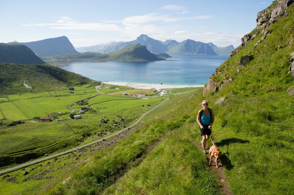
Most people finish the walk at the first peak at 931 metres. This is where you can enjoy the nicest picnic area and the great feeling of having reached the summit. You can admire the magnificent view of the emerald green sea and the beautiful beaches at Uttakleiv and Haukland. At the other side of Nappstraumen you will see the Lofoten wall stretching out towards the west.
At the highest point of Himmeltinden you can sign your name in the tour book.
Radar
At the northern and highest point of Himmeltiden (962 m) is the NATO radar. The radar was built in the 1980s in order to monitor the Norwegian airspace. There is a path over exposed terrain leading to the radar, but we do not recommend you go near the radar.
The Mannen mountain
As a supplement or alternative to climbing all the way up Himmeltinden, you can walk up to the Mannen mountain. This mountain is 400 metres above sea level, so it is not among the highest in Lofoten, but the view from the top is second to none.
To get to the top of Mannen, you follow the path towards the west from the cart road at the top of the pass between Uttakleiv and Haukland. The path has some exposed and steep parts and some climbing is required. On wet and rainy days, it may be slippery, so please be careful.
The old traffic route
There is an alternative travel route along the coast between Haukland and Uttakleiv. This is an easy walk on a flat, gravelled road and it is perfect if you prefer a less strenuous walk in beautiful surroundings.
From 1947 until the autumn of 1998, when the Uttakleiv tunnel was finished, this used to be the car road to Uttakleiv. The gravelled road follows around the mountain Veggen (“the Wall”). The road is built at sea level and it is surrounded by spectacular coastal nature. You can walk the road there and back or make a round trip over the mountain on the cart road, or you can make a round trip by walking back through the tunnel. On each side of the tunnel there is a box containing reflector vests. You can use a vest when going through the tunnel and then leave it in the box at the other side.
Frequently asked questions:
There is a free parking area at Haukland beach (per Oct 2020). In the summer season it can be difficult to find parking since this is a very popular recreational area.
The walk is fine for children who are used to demanding hikes. The terrain is steep, but there are no exposed parts.
Ja, men Vestvågøy kommune har en egen friluftsforskrift som regulerer hvor det er lov å sette opp telt på stranda.
Yes, you can bring a dog if it is used to high and steep terrain. Remember to keep the dog on a leash between 1. April and 1. October, AND as long as there are grazing animals in the area. The area has 1500 – 2000 grazing animals. Read more about how to care for the sheep here.