
Kvalvika and Ryten (543 mos)
Kvalvika and Ryten in Lofotenodden national park are some of the most popular hiking areas in Lofoten. And there is a good reason for that. The view from the top of Ryten far down to the long golden beach is second to none.
The hike to Kvalvika and Ryten attracts many people. This is where you experience the typical nature in Lofoten with steep mountains cliffs, emerald green sea and an impressive sandy beach, where it is tempting to go for a swim in the waves.
Unlike many other routes in the region that involve steep and demanding climbs, the trail to Ryten is more gradual and less physically challenging. The path takes you through varied and scenic terrain, offering changing views that make the journey enjoyable from start to finish. The hike up to Ryten is considered my many as “relatively accessible”.
Kvalvika is on the island Moskenesøy, but it belongs to the municipality of Flakstad. This area is known for its beautiful sandy beaches. In addition to Kvalvika, we also recommend the beaches at Yttersand, Ramberg and Skagsanden, which are worth a visit if you enjoy walking barefoot on the white coral sand.
The nearest shopping centre in this area is in Ramberg, which is 7 km from Indresand, where you start the hike. Ramberg has a petrol station, shops, tourist information, restaurants, cafes and accommodation. There are also a variety of water sport activities for children and grown-ups.
Important message Summer 2026 – From Lofotodden National Park
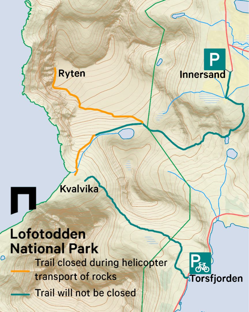
From 22 June to 30 September 2026, Lofotodden National Park is building and reinforcing the trails in Kvalvika and up to Ryten. Close to 90,000 people make this journey each year, and the wear on vegetation and terrain is visible. The work is being done to concentrate foot traffic, protect nesting sites for mountain birds, and preserve the landscape within the national park for the long term.
During the construction period, sections of the trail will be redirected around wherever the trail builders are working at any given time. Diversions are marked and staff are on site. Note that both trails, up to Ryten and down to Kvalvika, will be fully closed on days when helicopters are transporting materials to the area. These closures will be announced a few days in advance on social media and in the local newspaper. The trail from Torsfjorden into Kvalvika remains open as normal.
Find more information and operational updates from Lofotodden National Park: HERE.
🤝 Thank you for your understanding and have a great hike! 🤝
Parking
Many people enjoy going to Kvalvika. We recommend that you park at Fredvang school and start your hike from there, or at Innersand/Indersand. There is a sign pointing to this parking once you have crossed the Fredvang bridges. Follow the link below to find more information:

Terrain
From the parking, follow the sign to the path towards Einangen. This is a good path that goes through an easy terrain with small crags and hills. The path goes to the north of the lake Einangsvannet and south of the hill 290. Remember not to disturb the sheep and keep your dog on a leash.
Continue further up until you see the lake Forsvatnet further down on your left hand side. This is where the path splits in two directions, so you need to decide if you want to continue up to the top of the mountain or go directly down to the beach.
If you decide to go to the top of Ryten first, you just follow the path up the hill. The path divides into different routes. If you follow the path that goes along the edge on the left, you get the most spectacular view. But the cliffs are very steep, so please be careful!
Magnificent views
The view down to Kvalvika beach is impressive. Steep cliffs rise up on each side of the bay and create a beautiful frame around the beach.
When you approach the top of Ryten, the terrain becomes flatter. From the cairn at the top you get a great view over the open sea towards the north. What about doing this hike to see the midnight sun?
After having hiked to the top, many people like to go down to the beach. Maybe for a refreshing swim? Follow the path back down to the lake Forsvatnet and then follow the path from there down the hill towards the beach.
Round trip alternatives
You can make a round trip if somebody can drop you off and pick you up somewhere else along the route. The shortest route is from Kvalvika, over Skoren and down to Torsfjorden. The return trip can be cut shorter by going down to Torsfjorden on the eastern side of the lake Markvannet.
More useful advice
- If you require an experienced tour guide to accompany you on a hike, you may book hikes in many beautiful Lofoten mountains here.
- Take care of Lofoten when you visit – read more about how to be a responsible guest here.
- You find more information about Lofotodden national park here.
Frequently asked questions:
The hike is suitable for families with older children (10+ years old and upwards), that are used to hike in mountains. You may need to estimate more time if you bring younger children.
No, Kvalvika and Ryten are in the Lofotodden national park. In order to protect animal life and outdoor life, un-necessary noise must be avoided and the use of drones are not permitted in the Lofotodden national park.
Yes, but you need to keep your dog on a leash from the 1st of April to the 15th of November. Flakstad municipality has extended restrictions for dogs in order to protect grazing animals in the area. The path is suitable for dogs, but you may need to carry your dog over certain parts on the way down to Kvalvika.